Inyo National Forest is your gateway to the Eastern Sierra. Extending along the California and Nevada border Inyo National Forest is a land of superlatives – tall mountains, old trees, Mono Lake and iconic views, with a diversity of recreation opportunities to match.
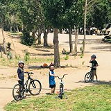
Inyo National Forest, Little Lakes Valley Trail, Bishop, CA 93514
583 views 💖 1 👍 0
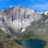
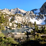
The easy access to this beautiful chain of lakes make Little Lakes Valley popular for fishing, day hikes and beginning backpackers. Glaciers carved this extensive chain of lakes, both large and small.
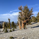
The Ancient Bristlecone Pine Forest is a renowned natural attraction located near Bishop, California, in the White Mountains of eastern California. The forest is part of the Inyo National Forest and is managed by the United States Forest Service. This forest is famous for its ancient bristlecone pine trees, some of which are among the oldest living organisms on Earth.
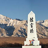
Manzanar is a historic site located in the Owens Valley of California, United States. It was the site of one of ten internment camps where Japanese Americans were forcibly relocated and detained during World War II.
Ubehebe Crater is a prominent volcanic feature located in the northern section of Death Valley National Park, California. It is part of the Ubehebe Craters volcanic field, which includes several overlapping craters formed by explosive volcanic activity. The largest crater is about 800 m (0.5 mi) wide and 250 m (800 ft) deep.
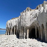
Crowley Lake Stone Columns were created by Eons old volcanic activity. These amazing formations are in the shape of helical columns. The stone columns are up to 20 feet tall and are connected by fortified stone arches.
Inyo County is a county located in the eastern part of California, United States. It is known for its spectacular natural beauty and is home to several national parks and wilderness areas, including Death Valley National Park, Mount Whitney, and the Ancient Bristlecone Pine Forest. In the 2020 census, the population was 19,016. The county seat is Independence.
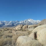
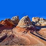
Located within the Alabama Hills National Scenic Area, photographers come from all over the country to capture this amazing view. The Arch Loop Trail was created in partnership with the Eastern Sierra Interpretive Association and the Alabama Hills Stewardship Group.
The Alabama Hills are a formation of rounded rocks and eroded hills set at the base of the jagged peaks of the Sierra Nevada. Both geologic features were shaped by the same uplifting occurring 100 million years ago.
The campsites at Rock Creek Lake sit on a low hill overlooking the lake with great views and a few trees. This 28 unit campground is a perfect location for limitless mountain recreation opportunities including fishing, camping, hiking and horseback riding at the nearby pack station.
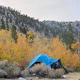
Onion Valley Campground is a quiet campground set amidst breathtaking scenery of rugged mountain peaks, thick forests and waterfalls in the Onion Valley area of the eastern Sierra Nevada Mountains.
Sad Boulders is a popular climbing area located in the Buttermilk Country just outside of Bishop, California. Known for its stunning granite boulders and picturesque surroundings, Sad Boulders offer a wide variety of climbing routes suitable for climbers of all skill levels. The area got its name from the unique shapes and formations of some of the boulders, which can resemble sad or drooping faces when viewed from certain angles.
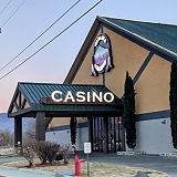
Wanaaha Casino is the best place for fun & entertainment in the Eastern Sierra. It offers the best slots machines, table games, great promotions, a fantastic restaurant, and the ultimate sports lounge.
The mission of the Museum of Western Film History is to collect, preserve, protect, archive and exhibit the history and heritage of American Western Films. The private institution has over 10,000 square feet of exhibits, an eighty-five seat movie theater and a gift shop.
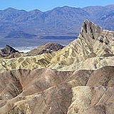
Zabriskie Point is a famous viewpoint in Death Valley National Park, California. Known for its dramatic and colorful landscape, it offers a stunning vista of the eroded and barren badlands of the Furnace Creek Formation. The landscape at Zabriskie Point has been shaped over millions of years through the erosion of sediments that were once part of an ancient lake bed.
The recreation facility is located off the highway next to Inyo’s Millpond County Park. 72 RV and tent sites are nestled in the foothills of the High Sierra and backed by the cool-running waters of a creek. Bring the family to a relaxing getaway at Brown’s Millpond Campground.
Baker Creek Campground is a picturesque camping area located near Big Pine, California, within the Inyo National Forest. The campground offers a variety of campsites suitable for tents, trailers, and RVs. Some sites are available on a first-come, first-served basis, while others can be reserved in advance.
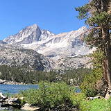
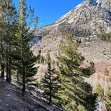
Treasure Lakes is a picturesque hiking destination located in the Eastern Sierra region of California, specifically within the Inyo National Forest. This area is renowned for its stunning alpine lakes, granite landscapes, and diverse recreational opportunities.
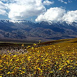
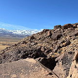
Encompassing the northern section of the Cosa Range, Coso Range Wilderness Area preserves an area of extensive erosion revealing outstanding displays of volcanic formations and numerous valleys and washes. From high points-primarily Joshua Flat in the east-central portion--you'll discover great views east into the Sierra Nevada and north into Owens Valley.