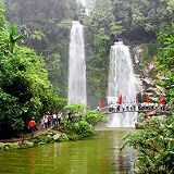
Thac Tien, also known as Fairy Falls, is a beautiful waterfall located in Xan Man district, Ha Giang province, Vietnam. It is situated near the Dao Gia³ (Windy Pass) area. Thac Tien and Dao Gia³ in Xan Man district of Ha Giang province offer acombination of natural beauty, cultural immersion, and adventurous exploration.
Cot Cu Lung Cu, also known as Lung Cu Flagpole, is a significant landmark located in Lung Cu commune, Dong Van district, Ha Giang province, Vietnam. Cot Cu Lung Cu is situated in the northernmost part of Vietnam, near the border with China. It is located in Lung Cu commune, which is approximately 24 kilometers from Dong Van town.
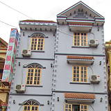
Pho co Dong Van is located in the middle of valley surrounded by rocks. The quarter is formed from the early 20th century, only has a few families of the H'mong, Tay and Chinese, gradually, more and more other local residents find it. The oldest house is the house of Luong family built since 1860.
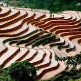
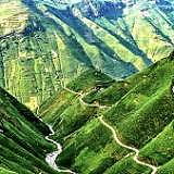
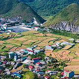
Hoàng Su Phì is a district located in Ha Giang province, Vietnam. It is known for its stunning terraced rice fields and picturesque landscapes. Hoàng Su Phì is situated in the northern part of Vietnam, bordering China. It is approximately 300 kilometers from Hanoi. The district is nestled in the Hoàng Su Phì mountainous area, which is part of the larger Hoàng Su Phì Son mountain range.
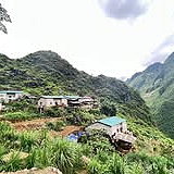
Can Ty is acommune located in Quan Ba District, Ha Giang Province, Vietnam. It is aremote and scenic areaknown for its untouched natural beauty and ethnic minority communities. Can Ty is situated in the northern part of Vietnam, in the mountainous region of Ha Giang Province. It is approximately 35 kilometers southwest of the provincial capital, Ha Giang City.
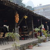
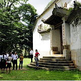
Dinh Vua Mao, also known as the Palace of Hmong King, is a historic building located in Xa Phin commune of Dong Van District, Ha Giang Province, Vietnam. The building was constructed during the late 19th century and served as the residence of the Hmong King in the region.
Ha Giang is a province in the Northeast region of Vietnam. It is located in the far north of the country, and contains Vietnam's northernmost point. It shares a270 km long border with Yunnan province of southern China, and thus is known as Vietnam's final frontier. It covers an area of 7,929.48 km2 (3,061.6 sq mi), comprising 1 city and 10 rural districts, with a population of over 850 thousand people as of 2019.
The Nho Que River (Sông Nho Quế) is a breathtaking and iconic natural landmark in the mountainous region of northern Vietnam. It's a key destination for travelers exploring the Ha Giang Loop and is renowned for its spectacular scenery and cultural significance.
Deo Ma Pa Lang is a famous mountain pass located in Ha Giang Province, Vietnam. It is known for its breathtaking and rugged landscapes, with towering limestone peaks, deep valleys, and a winding mountain road that offers stunning panoramic views. It is at the altitude of 1,500 m.
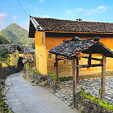
Lo Lo Chai (Lô Lô Chải) is a traditional village located in Dong Van Karst Plateau Geopark in Ha Giang Province, Vietnam. The area is famous for its stunning landscapes, ethnic diversity, and unique culture.
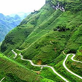
Quan Ba Heaven's Gate or Quan Ba Pass is a pass on National Highway 4C in Quan Ba District, Ha Giang Province, Vietnam. It is over 1,500m high, the starting point of another famous landmark "The Road of Happiness" and the first gateway to the majestic Dong Van Stone Plateau.
Mèo Vạc Valley (Thung Lũng Mèo Vạc) is a stunning region located in Hà Giang Province, Vietnam. Known for its breathtaking natural landscapes, it is a popular destination for travelers and adventure seekers. The valley is surrounded by towering mountains, lush green valleys, and picturesque villages, making it a perfect spot for hiking, trekking, and exploring rural life.
Dong Van Karst Plateau Geopark (Cao nguyên đá Đồng Văn) is located in Hà Giang Province, the northernmost province in Vietnam. It shares border with China in the north. It takes up most of the area of four of the province's districts: Mèo Vạc, Đồng Văn, Yên Minh, and Quản Bạ. The area of the geopark is 2356,8 km2. The average elevation within the geopark is 1400 to 1600 meters above sea level.