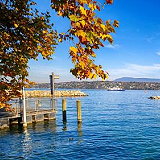
Lake Geneva is a deep lake located north of the Alps, within the shared territory of Switzerland and France. It is one of the largest lakes in Western Europe and the largest in the Rhône River basin. Sixty percent (345.31 km² or 133.32 sq mi) of the lake's area belongs to Switzerland (the cantons of Vaud, Geneva, and Valais) and forty percent (234.71 km² or 90.62 sq mi) belongs to France.
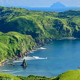
The Gulf of Bothnia is the northernmost part of the Baltic Sea, situated between the west coast of Finland and the northern part of the east coast of Sweden (and Norrbotten – North Bothnia). The gulf is divided into the Gulf of Bothnia, the Kvarken (northern), and the Sea of Bothnia. To the south of the gulf lies the island of Åland, situated between the Sea of Åland and the Archipelago Sea.
Lake Peipus is the largest transboundary lake in Europe, located on the border between Estonia and Russia. In Estonia, the lake is near the city of Tartu and covers an area of 3,555 km². Its average depth is 7.1 meters, with a maximum depth of 15 meters. Lake Peipus consists of three parts: a northern section, a southern section, and a central section that acts as a bridge between the other two.
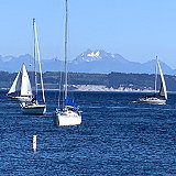
The Salish Sea is a marginal sea of the Pacific Ocean located in the province of British Columbia in Canada and the state of Washington in the United States. It includes the Georgia Strait, the Juan de Fuca Strait, Puget Sound, and a complex network of adjacent canals and waterways.
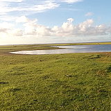
Lagoa Mirim is a large estuarine lagoon stretching from the southern part of the Rio Grande do Sul state in Brazil to eastern Uruguay. It is separated from the Atlantic Ocean by a sandy isthmus and is partly barren.
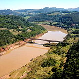
The Paraná River is a river in south-central South America, flowing through Brazil, Paraguay, and Argentina for approximately 4,880 km (3,030 miles). Among South American rivers, it is second only to the Amazon in length. The Paraná merges with the Paraguay River and then further downstream merges with the Uruguay River to form the Río de la Plata, which empties into the Atlantic Ocean.
The Irtysh River is a river that flows through Russia, China, and Kazakhstan. It is the main tributary of the Ob River and also the longest river in the world. Notably, it is nearly 600 km (373 mi) longer than the Ob. Its average depth ranges from 6 to 15 meters (20-49 ft).
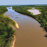
The Uruguay River is a major river in South America. It flows from north to south and forms part of the border between Brazil, Argentina, and Uruguay, separating several provinces of Mesopotamia in Argentina from the other two countries. Many people, animals, and plants depend on this river for survival, making it a vital waterway for both nature and humanity.
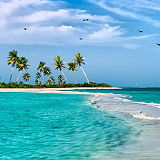
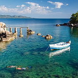
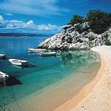
The Caribbean is a region of the Americas that consists of the Caribbean Sea, its islands, and the surrounding coasts. It's known for its stunning beaches, vibrant culture, and diverse history. Tourism is a major industry in the Caribbean, attracting millions of visitors each year to its beautiful beaches, clear waters for diving and snorkeling, and historical sites.
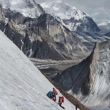
The Himalayas are one of the most awe-inspiring mountain ranges in the world, stretching across five countries: India, Nepal, Bhutan, China (Tibet), and Pakistan. This majestic range is home to the world's highest peaks, including Mount Everest, the highest point on Earth.
The Amazon River, located in South America, is renowned for being the largest river by discharge volume of water in the world. It discharges about 215,000–230,000 cubic meters per second, which is approximately 6,591–7,570 cubic kilometers per year. This volume is more than the next seven largest independent rivers combined and accounts for about 20% of the global riverine discharge into oceans.
The Strait of Hormuz is a strait between the Persian Gulf and the Gulf of Oman. It provides the only sea passage from the Persian Gulf to the open ocean and is one of the world's most strategically important choke points.
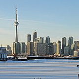
The Great Lakes are a group of five large freshwater lakes located in North America on the border between the United States and Canada. They are the largest group of freshwater lakes by total area in the world and hold about 21% of the world's surface fresh water.
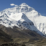
Mount Everest is the tallest mountain on Earth, with its summit reaching an elevation of 8,848.86 meters (29,031.7 feet) above sea level. It is located in the Himalayas on the border between Nepal and the Tibet Autonomous Region of China.
With the longest shoreline of all of the Great Lakes, Lake Huron is one of the most unique lakes on Earth. It is the second largest of the Great Lakes, and the fourth largest lake in the world by surface area. Huron is renowned for its beaches, sand dunes, wetlands, forests, and extensive river systems.
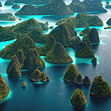
The Malay Archipelago also called Insulindia or the Indo-Australian Archipelago is the archipelago between Mainland Southeast Asia and Australia. Situated between the Indian and Pacific oceans, the archipelago of over 25,000 islands and islets is the largest archipelago by area and fifth by number of islands in the world.
The Ural Mountains, an ancient and majestic range, stand as a natural boundary between Europe and Asia. This geographical marvel has played a crucial role in shaping the historical, cultural, and even climatic aspects of both continents. The highest peak, Mount Narodnaya, rises to an elevation of 1,895 meters.
The Mozambique Channel is an arm of the Indian Ocean located between the Southeast African countries of Madagascar and Mozambique. The channel is about 1,700 km (900 nmi; 1,100 mi) long and 419 km (226 nmi; 260 mi) across at its narrowest point, and reaches a depth of 3,292 m (10,801 ft) about 230 km (124 nmi; 143 mi) off the coast of Mozambique.
Located between Alaska and Russia, the Bering Strait is the only marine gateway between the icy Arctic and the Pacific Ocean. At its narrowest point, the strait is only 55 miles wide. The Bering Strait may be narrow, but it’s teeming with wildlife—beluga whales, bowhead whales, gray whales, walruses, polar bears, ringed and ribbon seals.
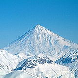
Mt.Makalu is 20 km east of Everest in the Khumbu region and is the fifth highest moutain in the world. The mountain lies in the Makalu Barun National Park and is known for its perfect pyramid shape with four sharp ridges.
Lake Superior is the largest freshwater lake in the world by surface area. It is the world's third-largest freshwater lake by volume and contains nearly 10% of the word’s fresh surface water. Lake Superior is relatively young, approximately 10,000 years old dating back to the last glacial retreat. The Lake Superior watershed includes the surrounding areas of Ontario, Minnesota, Wisconsin and Michigan.
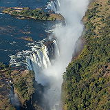
Victoria Falls is one of the most famous and spectacular waterfalls in the world. Located on the border between Zambia and Zimbabwe in Southern Africa. The falls were formed over millions of years by the geological activity that created the East African Rift System. The Zambezi River plunges into a series of gorges, creating the dramatic falls.
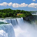
Niagara Falls is one of the most famous natural attractions in North America, known for its stunning beauty and immense power. Niagara Falls straddles the border between the United States and Canada, with two main sections: - Horseshoe Falls: The larger and more impressive of the two, located on the Canadian side. - American Falls: Located on the U.S. side, along with the smaller Bridal Veil Falls.
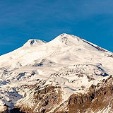
Mount Elbrus is the highest peak in Europe and one of the Seven Summits, a group of the highest mountains on each of the seven continents. Elbrus has two summits, both of which are dormant volcanic domes. The taller, western summit is 5,642 metres (18,510 ft);[2] the eastern summit is 5,621 metres (18,442 ft).
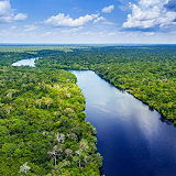
A mosaic of rivers, forests, savannas, swamps and flooded forests, the Congo Basin is teeming with life. Gorillas, elephants and buffalo all call the region home. The Congo Basin spans across six countries—Cameroon, Central African Republic, Democratic Republic of the Congo, Republic of the Congo, Equatorial Guinea and Gabon.
The Indian Ocean is the third-largest of the world's five oceanic divisions, covering 70,560,000 km2 (27,240,000 sq mi) or approx. 20% of the water on Earth's surface. It is bounded by Asia to the north, Africa to the west and Australia to the east. To the south it is bounded by the Southern Ocean, or Antarctica
The Atlantic Ocean is the second-largest ocean in the world, covering approximately 106.5 million square kilometers (41.1 million square miles). It separates the continents of Europe and Africa to the east from North and South America to the west. The deepest point in the Atlantic Ocean is the Milwaukee Deep in the Puerto Rico Trench, which reaches a depth of about 8,376 meters (27,480 feet).
The Pacific Ocean is the largest and deepest of Earth's five oceanic divisions. It extends from the Arctic Ocean in the north to the Southern Ocean in the south, and is bounded by the continents of Asia and Australia in the west and the Americas in the east.
The Alborz or Elborz Mountain range is a mountain range in northern Iran that stretches from the border of Azerbaijan along the western and entire southern coast of the Caspian Sea and finally runs northeast and merges into the smaller Aladagh Mountains and borders in the northeast on the parallel mountain ridge Kopet Dag in the northern parts of Khorasan.
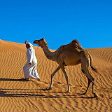
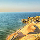
The Arabian Desert is a vast desert region that spans much of the Arabian Peninsula. The Arabian Desert covers parts of Saudi Arabia, Oman, Jordan, Iraq, Qatar, the United Arab Emirates, Kuwait, and Yemen. The desert features diverse landscapes, including vast sand dunes, gravel plains, rocky plateaus, and occasional mountain ranges.
The Strait of Malacca is a critical and strategic maritime passage that lies between the Malay Peninsula (Peninsular Malaysia) and the Indonesian island of Sumatra. The strait extends approximately 890 kilometers (550 miles) from the Andaman Sea to the South China Sea, narrowing down to about 2.8 kilometers (1.7 miles) at its narrowest point near Singapore.
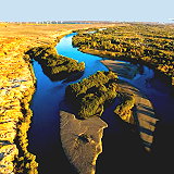
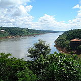
The Iguazu River is a significant waterway in South America. The Iguazu River flows through Brazil and Argentina. It forms part of the boundary between the two countries. The river is approximately 1,320 kilometers (820 miles) long. It originates near the city of Curitiba in the Brazilian state of Paraná and flows westward, eventually joining the Paraná River.
Lying between mainland China and the Korean peninsula, the Yellow Sea is one of the world's largest areas of continental shelf covered in shallow water, providing for rich fishing grounds and an important site for migratory birds. But decades of pollution is turning the sea to a colour other than yellow.
The Luzon Strait is the strait between Taiwan and Luzon, the northern portion of the Philippine archipelago. The strait thereby connects the Philippine Sea to the South China Sea in the western Pacific Ocean. This body of water is an important strait for shipping and communications. Many ships from the Americas use this route to go to important East Asian ports.
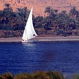
Nile River, the longest river in the world, called the father of African rivers. It rises south of the Equator and flows northward through northeastern Africa to drain into the Mediterranean Sea. It has a length of about 4,132 miles (6,650 kilometres) and drains an area estimated at 1,293,000 square miles (3,349,000 square kilometres).
The Alps are one of the most iconic mountain ranges in the world, spanning several European countries including France, Switzerland, Italy, Austria, Germany, and Slovenia. Renowned for their breathtaking beauty, diverse landscapes, and rich cultural heritage, the Alps attract millions of visitors each year for a wide range of outdoor activities and scenic experiences.
The Middle East is a region of significant historical, cultural, political, and economic importance. The Middle East typically includes countries in Western Asia and parts of North Africa. Some commonly included countries are: Saudi Arabia, Iran, Iraq, Israel, Jordan, Lebanon, Syria, Turkey, Yemen, United Arab Emirates, Qatar, Kuwait, Bahrain, Oman and Egypt, Libya.
The Karakoram is a major mountain range spanning the borders of Pakistan, India, and China, with its greatest part in the Gilgit-Baltistan region of Pakistan. It is one of the Greater Ranges of Asia, which also includes the Himalayas, Hindu Kush, and Pamirs.
The Great Sand Sea is an expansive region of sand dunes and desert located in the Sahara Desert, spanning the border between western Egypt and eastern Libya. The Great Sand Sea covers an area of approximately 72,000 square kilometers, stretching from the Siwa Oasis in Egypt to the Calanshio Sand Sea in Libya.
The Bashi Channel is a waterway between Mavulis Island of the Philippines and Orchid Island of Taiwan. It is a part of the Luzon Strait between the East China Sea and the South China Sea. It is characterized by windy storms during the rainy period, which lasts from June to December.
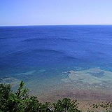
The Tyrrhenian Sea is part of the Mediterranean Sea off the western coast of Italy. It is named for the Tyrrhenian people, identified since the 6th century BC with the Etruscans of Italy. The sea is bordered by Corsica and Sardinia (to the west), the Italian peninsula the Tuscany Region, Lazio Region, Campania Region, Basilicata Region, and Calabria Region to the east, and Sicily (to the south).
The Ionian Sea is located between the countries of Italy, Greece and Albania and forms part of the Mediterranean Sea. In the north, this sub-sea is separated from the Adriatic Sea by the Strait of Otranto. In the south it passes directly into the Libyan Sea.
The Black Sea is an inland sea located between southeastern Europe and Asia Minor (modern-day Turkey). It is bounded by six countries: Bulgaria, Romania, Ukraine, Russia, Georgia, and Turkey. The Black Sea is connected to the Mediterranean Sea through the Bosporus Strait and the Sea of Marmara.
Lake Ontario is one of the five Great Lakes of North America and the easternmost of the group. Lake Ontario is bordered by the province of Ontario in Canada to the north, west, and southwest, and the state of New York in the United States to the south and east. It is the smallest of the Great Lakes by surface area but has significant depth.
The Caucasus Mountains are a prominent mountain range located at the intersection of Europe and Asia. They stretch between the Black Sea and the Caspian Sea and are divided into two main ranges: the Greater Caucasus and the Lesser Caucasus. The Caucasus Mountains span several countries, including Russia, Georgia, Armenia, and Azerbaijan. The length is approximately 1,200 kilometers (750 miles).
The Adriatic Sea is a body of water separating the Italian Peninsula from the Balkan peninsula. The Adriatic Sea is a part of the Mediterranean Sea. The countries with coasts on the Adriatic are Albania, Bosnia and Herzegovina, Croatia, Italy, Montenegro, and Slovenia.
The Sea of Azov is an inland shelf sea in Eastern Europe connected to the Black Sea by the narrow (about 4 km (2.5 mi)) Strait of Kerch, and sometimes regarded as a northern extension of the Black Sea. The sea is bounded by Russia on the east, and by Ukraine on the northwest and southwest (the parts of Ukraine bordering the sea are currently under Russian occupation).
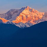
Kangchenjunga is the third highest mountain in the world. It rises with an elevation of 8,586 m (28,169 ft) in a section of the Himalayas called Kangchenjunga Himal that is limited in the west by the Tamur River and in the east by the Teesta River. The Kangchenjunga Himal is located in eastern Nepal and Sikkim, India.
Lake Tanganyika is one of the most remarkable natural features of East Africa and the world. The lake spans four countries: Burundi, Democratic Republic of the Congo (DRC), Tanzania, and Zambia. It is part of the East African Rift system. The lake is estimated to be 9–12 million years old, making it one of the oldest lakes in the world.
The Andaman Sea is a marginal sea of the northeastern Indian Ocean, located to the southeast of the Bay of Bengal. It is bordered by several countries, including: India to the north and northeast (specifically the Andaman and Nicobar Islands), Myanmar (Burma) to the east, Thailand to the southeast and Malaysia to the south.