
|
Zabriskie Point California Last Updated: 05/20/2024 |
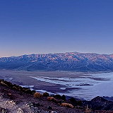
| Zabriskie Point is a famous viewpoint in Death Valley National Park, California. Known for its dramatic and colorful landscape, it offers a stunning vista of the eroded and barren badlands of the Furnace Creek Formation. The landscape at Zabriskie Point has been shaped over millions of years through the erosion of sediments that were once part of an ancient lake bed. | |

Wikipedia
Inyo County » Iny
Place » Outdoors
|
Dante's View Place » Outdoors Dante's View is a prominent viewpoint located in Death Valley National Park, California, at an elevation of approximately 5,475 feet (1,669 meters) above sea level. It offers stunning panoramic views of the surrounding landscape, including the vast expanse of Death Valley below, which features both the lowest point in North America at Badwater Basin and Telescope Peak, the highest point in the park. 214 views 💖 1 👍 0California |

|
Ubehebe Crater Place » Outdoors Ubehebe Crater is a prominent volcanic feature located in the northern section of Death Valley National Park, California. It is part of the Ubehebe Craters volcanic field, which includes several overlapping craters formed by explosive volcanic activity. The largest crater is about 800 m (0.5 mi) wide and 250 m (800 ft) deep. 503 views 💖 1 👍 0Furnace Creek, California |

|
Father Crowley Overlook Place » Outdoors Father Crowley Vista Point was a favorite stopping place for travelers. Located near the western park boundary, this vista point offers a stunning view into Rainbow Canyon, a colorfully striped canyon created by ancient volcanic activity. A short ¼ mile (400 m) walk or drive on an unpaved road leads from the vista parking area to Padre Point, overlooking Panamint Valley. 143 views 💖 1 👍 0Parking lot, CA-190, Inyo, CA |
|
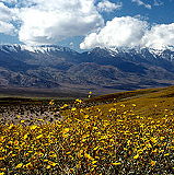
Inyo County Place » City Inyo County is a county located in the eastern part of California, United States. It is known for its spectacular natural beauty and is home to several national parks and wilderness areas, including Death Valley National Park, Mount Whitney, and the Ancient Bristlecone Pine Forest. In the 2020 census, the population was 19,016. The county seat is Independence. 450 views 💖 1 👍 0California |
|
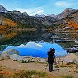
Lake Sabrina Place » Outdoors Lake Sabrina is a scenic alpine lake located in the Eastern Sierra region of Inyo National Forest, in the eastern part of Inyo County, in the eastern Sierra Nevada mountains of California. It is near the town of Bishop and is part of the Inyo National Forest. It is known for its stunning mountain scenery, clear waters, and recreational opportunities. 185 views 💖 1 👍 0Inyo County, California |
|
Olancha Peak Place » Outdoors Olancha Peak is a prominent mountain located in the Sierra Nevada mountain range of California, in Inyo County, California. It is approximately 50 miles south of Lone Pine and Independence and is easily visible from the Owens Valley. Olancha Peak has an elevation of 12,123 feet (3,695 meters) above sea level, making it one of the notable peaks in the Southern Sierra Nevada. 180 views 💖 1 👍 0California |
|
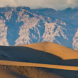
Mesquite Flat Sand Dunes Place » Outdoors The Mesquite Flat Sand Dunes are a popular attraction located in Death Valley National Park, California, United States. They are one of the largest sand dune complexes in the park, covering an area of over 14 square miles. 279 views 💖 1 👍 0Death Valley, CA 92328 |

|
Death Valley National Park Place » Outdoors Death Valley National Park is a vast desert wilderness located in eastern California, United States. It is one of the largest national parks in the country, covering over 3.4 million acres of rugged mountains, expansive sand dunes, and vast salt flats. 842 views 💖 1 👍 0California |