
|
Deo Ma Pi Leng Ha Giang, Vietnam Last Updated: 08/28/2025 |
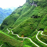
| Deo Ma Pa Lang is a famous mountain pass located in Ha Giang Province, Vietnam. It is known for its breathtaking and rugged landscapes, with towering limestone peaks, deep valleys, and a winding mountain road that offers stunning panoramic views. It is at the altitude of 1,500 m. | |
| Deo Ma Pa Lang is situated in the northern part of Vietnam, within the Dong Van Karst Plateau Geopark, a UNESCO-recognized global geopark. It is part of Ha Giang Province, near the border with China. The pass is famous for its dramatic and stunning natural beauty, characterized by steep limestone karst cliffs and deep canyons. The Nho Que River, which flows through the valley below, adds to the picturesque landscape. The mountain pass is traversed by the Ma Pa Lang Pass Road, a winding and challenging road that offers some of the most breathtaking views in Vietnam. The road is known for its hairpin turns and steep ascents and descents. - Cultural Significance: Deo Ma Pa Lang is not only a natural wonder but also holds cultural and historical significance. The area is home to several ethnic minority communities, including the Hmong, who have lived in the region for generations. - Adventure and Tourism: The pass and surrounding areas are a popular destination for adventure tourism, including motorbike tours, trekking, and photography. It is a destination for travelers seeking to experience the raw and untouched beauty of northern Vietnam. - Nho Que River: The Nho Que River, which runs through the valley beneath the pass, is a clear and pristine river known for its emerald waters. It offers opportunities for activities such as rafting and boating. - Local Markets: Visitors to the region can explore local markets and villages, where they can interact with ethnic minority communities and purchase handcrafted goods and local produce. - Weather: The weather in the Deo Ma Pa Lang area can vary, with hot summers and cold winters. It's important to check the weather and road conditions before traveling, especially during the rainy season. Deo Ma Pa Lang is a natural wonder of northern Vietnam, and it provides travelers with a unique opportunity to explore some of the most stunning and untouched landscapes in the country. It is an ideal destination for those who appreciate adventure, natural beauty, and cultural immersion. | |

Wikipedia
Vietnam » Ha Giang
Place » Outdoors

|
Song Nho Que Place » Outdoors The Nho Que River (Sông Nho Quế) is a breathtaking and iconic natural landmark in the mountainous region of northern Vietnam. It's a key destination for travelers exploring the Ha Giang Loop and is renowned for its spectacular scenery and cultural significance. 273 views 💖 1Huyen Mao Vac, Dong Van, Ha Giang, Vietnam |
|
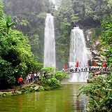
Thac Tien Place » Outdoors Thac Tien, also known as Fairy Falls, is a beautiful waterfall located in Xan Man district, Ha Giang province, Vietnam. It is situated near the Dao Gia³ (Windy Pass) area. Thac Tien and Dao Gia³ in Xan Man district of Ha Giang province offer acombination of natural beauty, cultural immersion, and adventurous exploration. 773 views 💖 2Dao Gia³, Xan Man, Ha Giang, Vietnam |
|
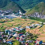
Cao Nguyen Dong Van Place » Outdoors Dong Van Karst Plateau Geopark (Cao nguyên đá Đồng Văn) is located in Hà Giang Province, the northernmost province in Vietnam. It shares border with China in the north. It takes up most of the area of four of the province's districts: Mèo Vạc, Đồng Văn, Yên Minh, and Quản Bạ. The area of the geopark is 2356,8 km2. The average elevation within the geopark is 1400 to 1600 meters above sea level. 154 views 💖 1QL4C, Xà Phìn, Đồng Văn, Hà Giang, Vietnam |
|
Cong Troi Quang Ba Place » Outdoors Quan Ba Heaven's Gate or Quan Ba Pass is a pass on National Highway 4C in Quan Ba District, Ha Giang Province, Vietnam. It is over 1,500m high, the starting point of another famous landmark "The Road of Happiness" and the first gateway to the majestic Dong Van Stone Plateau. 214 views 💖 1Quản Bạ, Hà Giang, Vietnam |

|
Ha Giang Place » City Ha Giang is a province in the Northeast region of Vietnam. It is located in the far north of the country, and contains Vietnam's northernmost point. It shares a270 km long border with Yunnan province of southern China, and thus is known as Vietnam's final frontier. It covers an area of 7,929.48 km2 (3,061.6 sq mi), comprising 1 city and 10 rural districts, with a population of over 850 thousand people as of 2019. 291 views 💖 1Vietnam |