
|
Song Nho Que Huyen Mao Vac, Dong Van, Ha Giang, Vietnam Last Updated: 08/28/2025 |
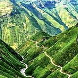
| The Nho Que River (Sông Nho Quế) is a breathtaking and iconic natural landmark in the mountainous region of northern Vietnam. It's a key destination for travelers exploring the Ha Giang Loop and is renowned for its spectacular scenery and cultural significance. | |
| Origin and Path: The river originates from the Nghiêm Sơn mountains in Yunnan Province, China, and flows for a total of 192 kilometers. Approximately 46 kilometers of its course are within Vietnamese territory, winding through the Ha Giang and Cao Bang provinces. The Tu Sản Canyon: The river is most famous for flowing through the majestic Tu Sản Canyon, which is considered the deepest canyon in Southeast Asia. This geological wonder is characterized by towering limestone cliffs that rise dramatically on either side of the emerald-green water. Ma Pi Leng Pass: The Nho Que River is often viewed from the famous Ma Pi Leng Pass, one of Vietnam's "Four Great Passes." The panoramic view from the pass, with the river snaking through the deep gorge below, is one of the most photographed and sought-after landscapes in the country. Distinctive Color: The river's water has a unique and striking turquoise or emerald-green color, which is particularly vibrant during the dry season. This hue, reflecting the surrounding limestone cliffs and lush vegetation, creates a stunning and almost dreamlike scene. Tourism and Activities: Boat Tours and Kayaking: One of the most popular activities is taking a boat tour or kayaking on the river. This allows visitors to get up close to the sheer cliffs of the Tu Sản Canyon and experience the tranquility of the water from a unique perspective. There are typically two main wharfs for these tours: Tà Làng and Xín Cái. Viewpoints: The best views of the river are from the Ma Pi Leng Pass and various other viewpoints along the Ha Giang Loop. These spots offer incredible photo opportunities and a chance to appreciate the scale of the landscape. Trekking and Hiking: The area around the river and the Ma Pi Leng Pass offers numerous trekking routes for adventurous visitors. Cultural Experience: The Nho Que River region is home to several ethnic minority groups, including the H'mong, Tay, and Dao communities. The river holds historical and cultural importance for these communities, and a visit provides an opportunity to learn about their traditions and way of life. | |

Website Wikipedia Facebook
Vietnam » Ha Giang
Place » Outdoors
|
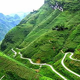
Deo Ma Pi Leng Place » Outdoors Deo Ma Pa Lang is a famous mountain pass located in Ha Giang Province, Vietnam. It is known for its breathtaking and rugged landscapes, with towering limestone peaks, deep valleys, and a winding mountain road that offers stunning panoramic views. It is at the altitude of 1,500 m. 240 views 💖 1Ha Giang, Vietnam |
|
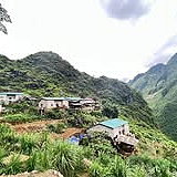
Cao Nguyen Dong Van Place » Outdoors Dong Van Karst Plateau Geopark (Cao nguyên đá Đồng Văn) is located in Hà Giang Province, the northernmost province in Vietnam. It shares border with China in the north. It takes up most of the area of four of the province's districts: Mèo Vạc, Đồng Văn, Yên Minh, and Quản Bạ. The area of the geopark is 2356,8 km2. The average elevation within the geopark is 1400 to 1600 meters above sea level. 154 views 💖 1QL4C, Xà Phìn, Đồng Văn, Hà Giang, Vietnam |
|
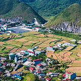
Thung Lung Meo Vac Place » Town Mèo Vạc Valley (Thung Lũng Mèo Vạc) is a stunning region located in Hà Giang Province, Vietnam. Known for its breathtaking natural landscapes, it is a popular destination for travelers and adventure seekers. The valley is surrounded by towering mountains, lush green valleys, and picturesque villages, making it a perfect spot for hiking, trekking, and exploring rural life. 183 views 💖 1QL4C, Pả Vi, Mèo Vạc, Hà Giang, Vietnam |
|
Cong Troi Quang Ba Place » Outdoors Quan Ba Heaven's Gate or Quan Ba Pass is a pass on National Highway 4C in Quan Ba District, Ha Giang Province, Vietnam. It is over 1,500m high, the starting point of another famous landmark "The Road of Happiness" and the first gateway to the majestic Dong Van Stone Plateau. 214 views 💖 1Quản Bạ, Hà Giang, Vietnam |

|
Ha Giang Place » City Ha Giang is a province in the Northeast region of Vietnam. It is located in the far north of the country, and contains Vietnam's northernmost point. It shares a270 km long border with Yunnan province of southern China, and thus is known as Vietnam's final frontier. It covers an area of 7,929.48 km2 (3,061.6 sq mi), comprising 1 city and 10 rural districts, with a population of over 850 thousand people as of 2019. 291 views 💖 1Vietnam |
|
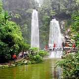
Thac Tien Place » Outdoors Thac Tien, also known as Fairy Falls, is a beautiful waterfall located in Xan Man district, Ha Giang province, Vietnam. It is situated near the Dao Gia³ (Windy Pass) area. Thac Tien and Dao Gia³ in Xan Man district of Ha Giang province offer acombination of natural beauty, cultural immersion, and adventurous exploration. 773 views 💖 2Dao Gia³, Xan Man, Ha Giang, Vietnam |