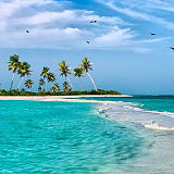
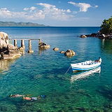
The Caribbean is a region of the Americas that consists of the Caribbean Sea, its islands, and the surrounding coasts. It's known for its stunning beaches, vibrant culture, and diverse history. Tourism is a major industry in the Caribbean, attracting millions of visitors each year to its beautiful beaches, clear waters for diving and snorkeling, and historical sites.
The Mediterranean Sea is a vast body of water bordered by Europe, Asia, and Africa, connecting to the Atlantic Ocean through the Strait of Gibraltar. It's one of the most historically significant bodies of water, known for its role in the development of ancient civilizations, trade routes, and cultural exchanges.
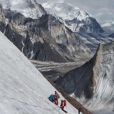
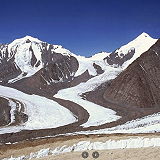
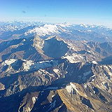
The Himalayas are one of the most awe-inspiring mountain ranges in the world, stretching across five countries: India, Nepal, Bhutan, China (Tibet), and Pakistan. This majestic range is home to the world's highest peaks, including Mount Everest, the highest point on Earth.
Mount Everest is the tallest mountain on Earth, with its summit reaching an elevation of 8,848.86 meters (29,031.7 feet) above sea level. It is located in the Himalayas on the border between Nepal and the Tibet Autonomous Region of China.
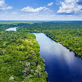
The Amazon River, located in South America, is renowned for being the largest river by discharge volume of water in the world. It discharges about 215,000–230,000 cubic meters per second, which is approximately 6,591–7,570 cubic kilometers per year. This volume is more than the next seven largest independent rivers combined and accounts for about 20% of the global riverine discharge into oceans.
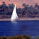
Nile River, the longest river in the world, called the father of African rivers. It rises south of the Equator and flows northward through northeastern Africa to drain into the Mediterranean Sea. It has a length of about 4,132 miles (6,650 kilometres) and drains an area estimated at 1,293,000 square miles (3,349,000 square kilometres).
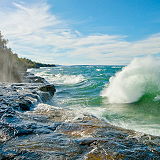
The Great Lakes are a group of five large freshwater lakes located in North America on the border between the United States and Canada. They are the largest group of freshwater lakes by total area in the world and hold about 21% of the world's surface fresh water.
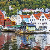
Scandinavia refers to the cultural and geographical region in Northern Europe that includes the countries of Norway, Sweden, and Denmark. Geographically, it's characterized by its northern location, with vast forests, rugged coastlines, fjords, and a relatively cold climate.
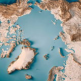
Antarctica is the southernmost continent on Earth, situated almost entirely within the Antarctic Circle. It's the fifth-largest continent by land area, covering approximately 14 million square kilometers (5.4 million square miles), making it larger than Europe and almost twice the size of Australia.
The Arctic Ocean is the smallest and shallowest of the world's five oceans, covering an area of about 14 million square kilometers (5.4 million square miles) at the North Pole. It is surrounded by the northern coastlines of North America, Europe, and Asia. The Arctic Ocean is unique for its ice cover, which varies significantly with the seasons, expanding in the winter and shrinking in the summer.
The North Pole is the northernmost point on Earth, located at the geographic North Pole, where the Earth's axis of rotation intersects its surface. It is situated in the Arctic Ocean and is surrounded by water covered by sea ice. Unlike the South Pole, which is located on the continent of Antarctica, the North Pole is not land but rather a point in the middle of the Arctic Ocean.
The Black Sea is an inland sea located between southeastern Europe and Asia Minor (modern-day Turkey). It is bounded by six countries: Bulgaria, Romania, Ukraine, Russia, Georgia, and Turkey. The Black Sea is connected to the Mediterranean Sea through the Bosporus Strait and the Sea of Marmara.
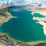
The Caspian Sea is the world's largest inland body of water, bordered by five countries: Russia, Kazakhstan, Turkmenistan, Iran, and Azerbaijan. Despite its name, the Caspian Sea is technically a lake, although it's often referred to as a sea due to its size and saline water. It spans an area of about 371,000 square kilometers (143,000 square miles) and has a maximum depth of over 1,000 meters (3,300 feet).
The Mekong River is one of the longest and most important rivers in Southeast Asia, flowing through six countries: China, Myanmar (Burma), Laos, Thailand, Cambodia, and Vietnam. It originates in the Tibetan Plateau of China and travels approximately 4,350 kilometers (2,703 miles) before emptying into the South China Sea.
The Alps are one of the most iconic mountain ranges in the world, spanning several European countries including France, Switzerland, Italy, Austria, Germany, and Slovenia. Renowned for their breathtaking beauty, diverse landscapes, and rich cultural heritage, the Alps attract millions of visitors each year for a wide range of outdoor activities and scenic experiences.
The Middle East is a region of significant historical, cultural, political, and economic importance. The Middle East typically includes countries in Western Asia and parts of North Africa. Some commonly included countries are: Saudi Arabia, Iran, Iraq, Israel, Jordan, Lebanon, Syria, Turkey, Yemen, United Arab Emirates, Qatar, Kuwait, Bahrain, Oman and Egypt, Libya.
The Karakoram is a major mountain range spanning the borders of Pakistan, India, and China, with its greatest part in the Gilgit-Baltistan region of Pakistan. It is one of the Greater Ranges of Asia, which also includes the Himalayas, Hindu Kush, and Pamirs.
The Great Sand Sea is an expansive region of sand dunes and desert located in the Sahara Desert, spanning the border between western Egypt and eastern Libya. The Great Sand Sea covers an area of approximately 72,000 square kilometers, stretching from the Siwa Oasis in Egypt to the Calanshio Sand Sea in Libya.
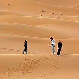
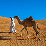
The Sahara Desert is the world's largest hot desert, spanning across North Africa. It covers approximately 9.2 million square kilometers, making it the third-largest desert globally, smaller only than Antarctica and the Arctic. The desert extends from the Red Sea in the east to the Atlantic Ocean in the west, and from the Mediterranean in the north to the Sahel savanna in the south.
The Hindu Kush is a significant mountain range in Central and South Asia, extending approximately 800 kilometers (500 miles) through Afghanistan and into northern Pakistan. Tirich Mir in Pakistan, which stands at 7,708 meters (25,289 feet), is the highest peak of the range. The range features rugged terrain with deep valleys and high, snow-covered peaks, making it a formidable barrier.
The Red Sea is a seawater inlet of the Indian Ocean, lying between Africa and Asia. It is one of the most significant bodies of water in the world due to its strategic location and rich biodiversity. The Red Sea is a popular destination for tourists, especially for diving and snorkeling, due to its clear waters and rich underwater ecosystems.
The Arabian Desert is a vast desert region that spans much of the Arabian Peninsula. The Arabian Desert covers parts of Saudi Arabia, Oman, Jordan, Iraq, Qatar, the United Arab Emirates, Kuwait, and Yemen. The desert features diverse landscapes, including vast sand dunes, gravel plains, rocky plateaus, and occasional mountain ranges.
The Strait of Malacca is a critical and strategic maritime passage that lies between the Malay Peninsula (Peninsular Malaysia) and the Indonesian island of Sumatra. The strait extends approximately 890 kilometers (550 miles) from the Andaman Sea to the South China Sea, narrowing down to about 2.8 kilometers (1.7 miles) at its narrowest point near Singapore.
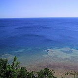
Lake Superior is the largest freshwater lake in the world by surface area. It is the world's third-largest freshwater lake by volume and contains nearly 10% of the word’s fresh surface water. Lake Superior is relatively young, approximately 10,000 years old dating back to the last glacial retreat. The Lake Superior watershed includes the surrounding areas of Ontario, Minnesota, Wisconsin and Michigan.
With the longest shoreline of all of the Great Lakes, Lake Huron is one of the most unique lakes on Earth. It is the second largest of the Great Lakes, and the fourth largest lake in the world by surface area. Huron is renowned for its beaches, sand dunes, wetlands, forests, and extensive river systems.
Lake Ontario is one of the five Great Lakes of North America and the easternmost of the group. Lake Ontario is bordered by the province of Ontario in Canada to the north, west, and southwest, and the state of New York in the United States to the south and east. It is the smallest of the Great Lakes by surface area but has significant depth.
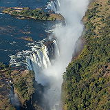
Victoria Falls is one of the most famous and spectacular waterfalls in the world. Located on the border between Zambia and Zimbabwe in Southern Africa. The falls were formed over millions of years by the geological activity that created the East African Rift System. The Zambezi River plunges into a series of gorges, creating the dramatic falls.
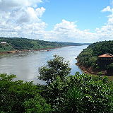
The Iguazu River is a significant waterway in South America. The Iguazu River flows through Brazil and Argentina. It forms part of the boundary between the two countries. The river is approximately 1,320 kilometers (820 miles) long. It originates near the city of Curitiba in the Brazilian state of Paraná and flows westward, eventually joining the Paraná River.
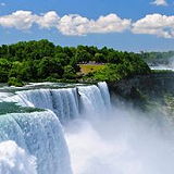
Niagara Falls is one of the most famous natural attractions in North America, known for its stunning beauty and immense power. Niagara Falls straddles the border between the United States and Canada, with two main sections: - Horseshoe Falls: The larger and more impressive of the two, located on the Canadian side. - American Falls: Located on the U.S. side, along with the smaller Bridal Veil Falls.
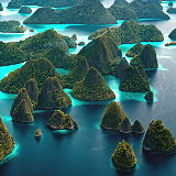
Oceania is a geographic region that includes Australasia, Melanesia, Micronesia, and Polynesia. Spanning the eastern and western hemispheres, it comprises numerous islands in the Pacific Ocean, including the continent of Australia. Oceania is a diverse and fascinating region, offering a blend of unique cultures, stunning natural environments, and complex histories.
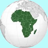
Africa is a diverse and vast continent composed of 54 countries, each with its own unique cultural, historical, and geographical attributes. Africa is traditionally divided into several regions, including North Africa, West Africa, Central Africa, East Africa, and Southern Africa.
Europe is a continent located entirely in the Northern Hemisphere and mostly in the Eastern Hemisphere. It comprises the westernmost part of Eurasia and is bordered by the Arctic Ocean to the north, the Atlantic Ocean to the west, the Mediterranean Sea to the south, and Asia to the east.
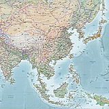
Asia, the largest continent on Earth, is a diverse and culturally rich region encompassing a wide range of environments, economies, and societies. It has approximately 44.58 million square kilometers (17.21 million square miles) with over 4.6 billion people, making up about 60% of the world's population.
South America is the fourth largest continent in the world, located entirely in the Western Hemisphere. It's bordered on the west by the Pacific Ocean, on the north and east by the Atlantic Ocean, and by the Caribbean Sea to the northwest. South America is connected to North America by the Isthmus of Panama. It had a population of 434,254,119 in 2021.
The Andes Mountains are a vast and beautiful mountain range that runs along the entire western coast of South America. The range stretches over 4,000 miles, from Colombia in the north, through Ecuador, Peru, Bolivia, Chile, and Argentina, and ending at Tierra del Fuego, the southernmost tip of the continent.
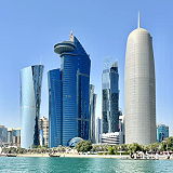
The Persian Gulf, also sometimes called the Arabian Gulf, is a body of water located in Western Asia. It is an extension of the Indian Ocean that lies between Iran and the Arabian Peninsula. The Persian Gulf is bordered by eight countries: Iran, Iraq, Kuwait, Saudi Arabia, Qatar, Bahrain, United Arab Emirates, and Oman.
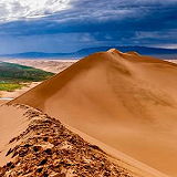
Stretching across southern Mongolia and northern China, the Gobi Desert stands as one of the most captivating and enigmatic landscapes on the planet. Covering an area of over 1.3 million square kilometers, it is the largest desert in Asia and the fifth-largest desert in the world.
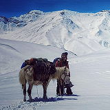
The Arctic Desert, also known as the Arctic Tundra, is a cold, desolate region that encircles the North Pole, encompassing parts of Alaska, Canada, Greenland, Iceland, Norway, Sweden, Finland, and Russia. The Arctic Desert experiences extremely cold temperatures, often dropping below -40°C (-40°F) in winter. Summers are short and cool, with average temperatures ranging from 3°C to 12°C (37°F to 54°F).
The Tibetan Plateau, also known as Qinghai–Tibet Plateau and Qing–Zang Plateau, spans across multiple countries including China, India, and Bhutan as well as Gilgit-Baltistan in Pakistan, northwestern Nepal, eastern Tajikistan and southern Kyrgyzstan. It is surrounded by the Himalayas to the south, the Kunlun Mountains to the north, and various mountain ranges to the east and west.
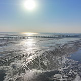
Lying between mainland China and the Korean peninsula, the Yellow Sea is one of the world's largest areas of continental shelf covered in shallow water, providing for rich fishing grounds and an important site for migratory birds. But decades of pollution is turning the sea to a colour other than yellow.
The Amazon River Basin is home to the largest rainforest on Earth. The basin -- roughly the size of the forty-eight contiguous United States -- covers some 40 percent of the South American continent and includes parts of eight South American countries: Brazil, Bolivia, Peru, Ecuador, Colombia, Venezuela, Guyana, and Suriname, as well as French Guiana, a department of France.
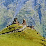
The Caucasus Mountains are a prominent mountain range located at the intersection of Europe and Asia. They stretch between the Black Sea and the Caspian Sea and are divided into two main ranges: the Greater Caucasus and the Lesser Caucasus. The Caucasus Mountains span several countries, including Russia, Georgia, Armenia, and Azerbaijan. The length is approximately 1,200 kilometers (750 miles).
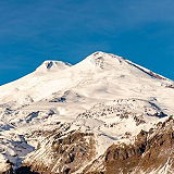
Mount Elbrus is the highest peak in Europe and one of the Seven Summits, a group of the highest mountains on each of the seven continents. Elbrus has two summits, both of which are dormant volcanic domes. The taller, western summit is 5,642 metres (18,510 ft);[2] the eastern summit is 5,621 metres (18,442 ft).
The Caucasus, a mountainous isthmus of land sandwiched between the Black Sea and the Caspian Sea, is a region that includes parts of six countries – Russia, Georgia, Azerbaijan, Armenia, Turkey and Iran. It is home to the Greater and Lesser Caucasus Mountains, two of the world’s great mountain ranges and home to the highest peaks in Europe.
A mosaic of rivers, forests, savannas, swamps and flooded forests, the Congo Basin is teeming with life. Gorillas, elephants and buffalo all call the region home. The Congo Basin spans across six countries—Cameroon, Central African Republic, Democratic Republic of the Congo, Republic of the Congo, Equatorial Guinea and Gabon.
The Malay Archipelago also called Insulindia or the Indo-Australian Archipelago is the archipelago between Mainland Southeast Asia and Australia. Situated between the Indian and Pacific oceans, the archipelago of over 25,000 islands and islets is the largest archipelago by area and fifth by number of islands in the world.
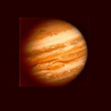
Jupiter is the largest planet in the solar system and the fifth planet from the sun. The gas giant has a long, rich, history of surprising scientists. Jupiter has 79 moons and is known as the 'king of the planets'. Jupiter orbits the Sun at a distance of 5.20 AU (778.5 Gm) with an orbital period of 11.86 years.
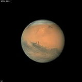
Mars is the fourth planet from the sun and has a distinct rusty red appearance and two unusual moons. The Red Planet is a cold, desert world within our solar system. It has a very thin atmosphere, but the dusty, lifeless planet is far from dull. The surface of Mars is orange-red because it is covered in iron oxide dust, giving it the nickname "the Red Planet".
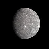
Mercury is the smallest planet in the Solar System and the closest to the Sun, with a diameter of about 4,880 km. It has a dense metallic core, constituting roughly 75% of its volume, and a thin silicate crust23. Mercury's surface is heavily cratered due to impacts over billions of years, featuring notable formations like the Caloris Basin34.
The Indian Ocean is the third-largest of the world's five oceanic divisions, covering 70,560,000 km2 (27,240,000 sq mi) or approx. 20% of the water on Earth's surface. It is bounded by Asia to the north, Africa to the west and Australia to the east. To the south it is bounded by the Southern Ocean, or Antarctica